<img height="1" width="1" style="display:none" src="https://www.facebook.com/tr?id=192888919167017&amp;ev=PageView&amp;noscript=1">
Thursday,  April 25 , 2024

Linkedin Pinterest
News / Sports / Outdoors

Off the beaten path in Alaska

Travelers leave roads behind in Noatak River trip

By Eli Francovich, The Spokesman-Review
Published: October 5, 2022, 6:05am
2 Photos
Alaska's Noatak River as seen on July 28, from the air.
Alaska's Noatak River as seen on July 28, from the air. (Eli Francovich/The Spokesman-Review) Photo Gallery

KOTZEBUE, Alaska — The plane banks, straightens and begins its descent. I wake groggy from the half sleep of travel. Out the window, clouds whip past and break apart revealing far-north Alaska. Treeless tundra, standing water pooled by the permanent layer of frost lurking below. Kotzebue, a speck of a town bounded on three sides by salt water and accessible only by air or boat, is our destination. The Alaska Airlines 747 descends, fighting the coastal wind and rain.

I’m here with Chris Kopczynski, his brother Cary Kopczynski and Jim Wood. We hustle out of the plane and into the rain, gathering our gear (50-pound kayak, 20-pound carry-on, 50-pound duffel full of food, clothing and other things) and call Husky Cab, one of the three cab companies servicing the 3,000 or so residents.

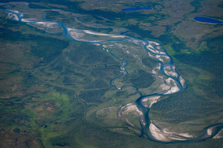
Which brings me to the roads. For most of us, geography is defined by roads. This holds true whether you’re in the city (turn right on Monroe, Siri drones) or in the country (stay left at the fork). Our spherical world is organized around straight lines. Not so in Alaska, particularly the farther north you go. Alaska has about 15,000 miles of public roads, accounting for a tiny fraction of the United States’ more than 4 million miles of road. This lack is visible from the air, even flying into and out of Anchorage to say nothing of Kotzebue, which as of 2013 contributed 28 miles of road (only 7 miles of which are paved) to these totals.

A battered and mud-stained minivan drives us three or four blocks to the one hotel in town. The Nulla’vik Hotel is owned by the Alaska Native Corporation and has the feeling of a Marriott, replete with a small concession stand and Starbucks coffee every morning. The hotel is roughly 100 yards from the sea and stands in stark contrast to the muddy streets lacing between low-slung prefab buildings, weathered from the elements, yards full of machines: Land-locked snowmobiles waiting for winter, decomposing motorbikes, trucks slowly diving back into the earth.

It’s raining and windy and the clouds sit low, which leads to much prognosticating about whether we’ll fly north on the bush plane tomorrow. All three men I’m with have some experience with bush planes and their operational tolerances. I, knowing nothing, stay quiet. Cary Kopczynski calls the bush pilot. We will meet him tomorrow at 8 a.m., and see if we can fly. Chris, a veteran of more expeditions than he can count, doesn’t think we will. Waiting is part of the game, he says.

July 26: We meet Eric Sieh, the owner of Arctic Backcountry Flying Services, this morning. Taciturn, although not unfriendly, he wears cowboy boots and has a wide-legged swagger reminiscent of Han Solo. He doesn’t talk much, although his silence isn’t unfriendly. As we fiddle with gear, he spends 10 minutes wiping down one of his planes, going over every inch with a hand rag. Then, glancing out the window he says, “I’m not ruling it out,” and tells us to leave and call him in a few hours to see what’s happened with the weather.

The day is languid. It reminds me of island life, hours inching away, and for the first time in three years I’m nearly completely disconnected from the virtual world. Cell service is mostly nonexistent for Verizon, and I didn’t bring my laptop. I nap and read and run as we wait. This languorous existence is juxtaposed against the wind and rain, which is nearly constant. Around 1 p.m., anxious to get moving, we walk back to the hangar. Not today, we’re told.

July 27: The Noatak River starts at the base of the 8,510-foot Mount Igikpak and then winds its way 300, or 350 or 400 miles to the sea. The listed mileages vary, as does the river’s path. During the winter, it’s a ribbon of ice. Every spring it thaws screeching and booming its way to freedom. The river’s course always shifting. Cary believes we can easily paddle the entire thing, including rests days. Chris is more pessimistic. Either way, we aren’t flying today, low-slung clouds and icy rain still dominating the sky. Our day is organized around the next meal, nothing to do but wait and eat.

July 28: The weather has cleared and today we fly. Eric has already taken Cary and Jim. Chris and I drink coffee and double-check that our gear is ready and then, about noon, Eric returns, we load up and we’re off.

For 185 miles we fly, seeing nothing of human design. Tundra and mountain below and as far as the eye can see to either side. Eric becomes more talkative once he’s in the air. He tells us about moving here when he was 18 from the Lower 48 and learning to fly and about the animals he’s seen, stalked and killed. More and more people who come up here don’t seem prepared, he says. They have grand visions of adventure but no understanding of the skills and grit it takes to survive. Instead, they’re filled with images from TV and movies, emboldened by the fact that satellite communications have made it possible to call for help from nearly anywhere in the world.

Don’t worry about the bears, he says, although he’s also quick to ask if we have a gun. We do. Two shotguns loaded with slugs and twice as many cans of bear spray.

From the air the task ahead becomes more obvious. This is huge country and we plan to paddle it.

Loading...